Antalya Köprüçay River
 Emerging from the Toros (Taurus) Mountains and running through a number of amazing canyons, Koprucay flows into the Mediterranean Sea to the south of Serik.
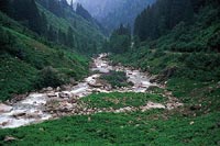
Fed by underground springs in gorges that cut through steep, impassable canyons, the Koprucay constitutes one of Türkiye's most beautiful natural recreation areas. The numerous archaeological sites in the area, especially the ancient city of Selge (Zerk), the fortresses on the banks of the river, arched Roman bridges and historic roads add to the significance of the Koprulu Canyon.
Koprucay is reached from Antalya via Serik, Tasagìl and Beskonak. Those coming from Manavgat can reach Beskonak via Tasagil. The asphalted road to Beskonak follows the Koprucay in various places.
Koprulu Canyon National Park covers 36,000 hectares, including part of Koprucay and the ancient city of Selge. As Türkiye's largest forest of Mediterranean Cypress, the National Park is rich in red pine, black pine, cedar, fir, oak and wild olive trees. The wild animals in the region include fallow deer, wild goat, wild boar, bear, wolf, fox, rabbit and various bird species. There are red speckled trout in the upper reaches and grey mullet in other parts of the Koprucay.
Course
Approximately 100 m before Oluk Bridge, the water and the river are still forms a pool. This is a good spot to start your trip and gives an inexperienced crew time to get used to the rowing technique. The bridge is reached by paddling against the current. Less experienced groups usually enter the canyon from the Oluk Bridge, while professionals may do so either from the falls near the start or from the Oluk Bridge, turning around further ahead to start the trip. The course continues after passing the falls, and areas of class 2-3 water.
The falls along the river add to the beauty of the landscape. After each waterfall, the Koprucay slows down, giving time to enjoy the majestic setting.
A concrete bridge is 10 km down the river, and novices should complete their journey immediately before this point. Experienced rowers can continue into the first canyon after the bridge, but the second canyon is strictly off limits, since the river runs under rocks in paces. After disembarking at the end of the first canyon, which is about 3 km long, the left bank leads to an asphalt road.