Artvin Çoruh River
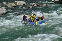 The River Coruh cuts through the mountainous region of Artvin and reaches the Black Sea. Beginning at the Mescit Mountains (3225m), it flows for 466 km before reaching the Black Sea in Georgia, and is one of the fastest flowing rivers in the world. Every year, local and foreign watersports enthusiasts travel to the area for canoeing, rafting and trekking in the Kackar Mountains. The small towns and villages located along the river are historically interesting, and the whole area represents the combination of Eastern Anatolian and Black Sea cultures.
The best way to reach the summit at Kackar Mountains is via the village of Yaylalar, from where local guides and mules can be hired to carry personal belongings. The natural habitat of Coruh River remains undisturbed, and colonies of red vultures, which are threatened with extinction, live among the rocks by the riverside. The area surrounding the river is rich in wildlife, including grey bear, mountain goat with hooked horns, wild boar, wolf, jackal, fox, badger, water sable, rabbit, partridge, wild rooster, woodcock, wild duck, stock dove and golden oriole.
Courses
A trip down the River Coruh starts at Bayburt, passing through Ispir and Yusufeli and onwards to Artvin, a distance of approximately 260km in four different sections.
Bayburt - Ispir (0-106 km): The Dikmetas Bridge near Bayburt is an ideal starting point for this expedition, and has good areas for camping on either side of the river. Aslandede and Laleli are the pleasant campsites for the second camp.
With a class 2-3 water, the trip from Bayburt to Ispir can be completed within three days on average. Approximately 3 km before arriving at Ispir, the left bank has a good place for camping. The nearby gas station and the shops in Ispir are useful for stocking up on supplies.
Ispir - Camlikaya (106-134 km): After leaving Ispir by road, there are rapids at 3km, 6.6km, 7.4km, and 8km. The small hut on the left side of the road before the Camlikaya junction 28km, makes a good rest stop. Drinking water can be obtained either from the brook flowing from the mountains, 200m ahead on the left side of the road, or from the spring to the right of the transformer station past the concrete bridge at the Camlikaya road junction. Food can be bought can be bought from Camlikaya (4km from the junction). The Ispir-Camlikaya route is class 3-4-5 water.
Camlikaya - Tekkale (134-178 km): After Camlikaya, the river banks are full of rice plantations, vegetable gardens and fruit orchards. The river passes Koprugoren at 48km, approaching the hamlet of Alanbasi at 54km. Camping is possible next to the brook that joins the Coruh on the left bank immediately before the village.
Past the concrete bridge, the river becomes rockier, with class 3-4-5 water. An old watchtower is visible before arriving at Cevreli. The garden in front of the village primary school, to the right immediately after the concrete bridge, makes a good campsite. There are also places for overnight stay in Tekkale, 7 km ahead. From Tekkale, local guides can take you up the mountains to see the historic Dortkilise, a medieval Georgian church. Fishermen will enjoy angling for speckled trout (alabalik) in the brook flowing nearby the church.
Tekkale - Artvin (178-261 km): From Tekkale, the expedition proceeds to Yusufeli, 6km away, which has accommodation and simple cafes. The Altiparmak (Barhal), one of the major branches of the Coruh, joins the river close to Yusufeli. As the flow-rate of the river picks up speed, the route becomes increasingly challenging, with class 3-4-5 water.
Oltu Cayi joins the river 9km after Yusufeli, near the Artvin-Erzurum highway junction, behind a concrete bridge. The rapids begin 22 km from Yusufeli.
This 100m stretch of white water, nicknamed King Kong, cascades around sharp boulders with breathtaking velocity, making it the high point of the expedition. The water is dangerous here, class 5+ water, so those with less experience should not plan to cross this section when the river is high. A large concrete sign inscribed with the letters EIE to the left of the highway identifies this section of the Coruh.
There is a good place to camp 33 km before Zeytincik, stopping to pick up any necessary provisions in the village. At 43 km, the river enters a narrow 3 km long canyon, class 3-4. The gas station and inn at Oruclu, at 57 km, provides a convenient finishing point for the trip. Boats can be pulled on shore here, and there are a few basic rooms and a cafe. Artvin is 20 km further on from Oruclu, with mostly class 1-2 water. Some groups prefer to extend the route right through to Artvin.