Antalya Highlands
 Finike - Ördübek Highland
Transportation: After going 41 km west on the Finike-Elmalı highway, turn left (west) on to the gravel road and continue to go for another 6 km. in order to reach the village. In the summer there are minibuses from Finike.
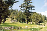
Description: This spacious mountain plateau is surrounded by century-old cedar and juniper trees and the meadows are covered with wildflowers. The fact that there are very few houses and no infrastructure whatsoever has preserved the natural beauty of this magnificent highland area. The ruins of the ancient city of Arycanda in the village of Arif can be toured as well.
Accommodation - Food and Drink: Those who plan on camping should bring their own tents and other basic supplies.
Serik - Ovacık Highland
 Transportation: Seven kilometers of the 36 km. drive from Serik is asphalt, the rest of the road is gravel. Another way to get there is by taking the Serik - Antalya highway, and when you have gone 8 km. take the right (north) passing through the villages of Candır, Alacami and Etler. It is a total of 48 km.
Description: The view from the road as you leave the citrus groves of Serik and begin climb among the pines is impressive. The panoramic vista of the Mediterranean that you have at the entrance to the highland village of Nanalı is like something you would expect to find in a postcard shop.
It is surrounded on every side by steep forested slopes, the Ovacık highland has no facilities. The banks of the stream which runs through this pristine meadow makes a good camping spot. One will also find the ruins of an ancient castle here.
Accommodation - Food and Drink: Those who plan on camping should bring their own tents and other basic supplies.
Saklıkent (Saklı) Highland
Transportation: The scenic road to the highland is asphalt for 10 km. and the rest is gravel.
Description: Located on the northwest of Antalya in the middle of the Beydağları mountain range at an elevation of 1850 m., the highland village of Saklıkent also has ski facilities.
It is a popular place for local people of Antalya, and the highland is an excellent camping and picnic area with Karçukuru, Fesikan highland, Yazır highland, Moryer, Mt. Eren, Fesleğen highland, Yazır ridge and Bereket Mountain all nearby.
Accommodation - Food and Drink: Some houses can be rented and there are large markets and restaurants in town.
Alanya - Demirtaş Nahiyesi Kaş - Sapadere - Tokar and Söğüt Highlands
Transportation: These highlands up in the middle of the Taurus Mountains north of Demirtaş can be reached by a gravel road out of Demirtaş Nahiyesi. The highland of Kaş is 30 km, Sapadere 35 km., Tokar 40 km., and Söğüt is 50 km. At certain times of the day during the summer months there are minibuses going to these highland villages.
Description: The scenic road to the highlands which sometimes runs alongside Demirtaş Creek winds through citrus groves, green houses, scrub trees and finally pine forests. The highlands are frequented by the residents of Demirtaş and the surrounding villages. Fruit orchards, wildflowers and mountains meadows abounded in these pristine highlands. In the nearby villages there are tea houses and restaurants. Telephones are available. You can camp on the banks of Demirtaş Creek and fish with a rod and reel.
Accommodation - Food and Drink: Those who plan on camping should bring their own tents and other basic supplies. 
Üçoluk Highland
Transportation: It is 37 km from Kemer on a gravel road that passes through a pine forest.
Description: Located southwest of Antalya at an elevation of approximately 1500 m., this area has an abundance of wild plants and animals. The simple highland village, which has no electricity or post office, seems to have become one with the forest of cedar, pine and sycamore. Besides the visitors from nearby Antalya and Kemer, travel agencies frequently arrange hiking and camping tours here.
Accommodation - Food and Drink: Those who plan on camping should bring their own tents and other basic supplies.
Akseki - Piser Highland
Transportation: You need to take the Antalya-Akseki-Beyşehir highway and 9 km. past Akseki and then turn west onto a gravel road. The village is 3 km down this road.
Description: Situated in a broad flat valley, this unspoiled highland is covered with fir and pine trees and interspersed with mountain meadows covered with wildflowers.
Without electricity or even a post office, this quiet, relaxing highland is perfect for those who want a holiday away from it all. There are a number of things to do there. One can explore Altınbeşik (10 km.), a cave of rare beauty, fish on the banks of Manavgat Creek, or go to the nearby village of Akşahap and get a close-up look at village life.
Accommodation - Food and Drink: Those who plan on camping should bring their own tents and other basic supplies.
İbradi - Maşad - Kocaoluk - Sütleğen - Elmalı - Gebesin - Söğütbeli -Sülek Highlands
Transportation: These highlands are found along the İbradı - Beyşehir road or very close to it.
Description: The foothills of Hasan Mountains rise up to 1200-1500 m. This highland area with its simple stone houses is covered with pine, fir and cedar trees. İbradı, which is famous for its vineyards and wine, is one of the few places where one can find houses built in the old Turkish style. You can explore Altınbeşik cave, one of the largest caves in Türkiye (12 km.) or Düdencik cave (15 km.)
This area has abundant wildlife including mountain goats, partridges, foxes, rabbits, wild hogs and fieldfare birds.
Accommodation - Food and Drink: Those who plan on camping should bring their own tents and other basic supplies.
Alanya - Dereköy Highland
 Transportation: The road leading to this highland village north of Alanya is asphalt (30 km.)
Description: The village is nestled among fruit orchards and vegetable gardens on the southern slopes of the small valley formed by Kargı Creek. Frequently used as a stopping place by foreign and local tourists alike, the village has tea houses, markets, a health clinic and restaurants. It is an ideal place for a day trips, picnics and excursions into the forest.
Accommodation - Food and Drink: Most basic necessities can be purchased here.
Serik - Beşkonak - Altınkaya (Zerk - Selge) - Ballıbucak Villages, Gödre and İkiz Highlands 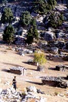
Transportation: Minibuses from Serik travel to the village along a 35 km asphalt road that winds through citrus groves and pine trees. There is a 10 km. gravel road that leads to the villages of Beşkonak Altınkaya (the ancient city of Selge-Zerk) and passes through the Köprülü Canyon National Park. If you turn west (left) 3 km. out on the road leading to the villages of Altınkaya and Ballıbucak and follow the path another 3 km., you will arrive at the highland of İkiz.
Description: The elevation of these highlands north-northwest of Antalya in the foothills of Mr. Kuyucak is 1600 - 1900 m. There are no facilities here among the pine, fir, juniper and cedar forests. There is no way to get to the highland meadow of İkiz by car. This area is used by the nearby villagers as pasture for their animals.
Accommodation - Food and Drink: Those who plan on camping should bring their own tents and other basic supplies.