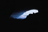
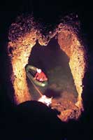
Caverns of Antalya
Geyikbayırı Cavern
Location: Antalya
The cavern is at the Geyikbayırı village which is 26 km to Antalya. In order to reach Geyikbayırı village, Çakırlar Köyü which is to the west from Antalya could be used. To reach the cavern, a 5 minute trekking from the center of the village is enough.
Properties: The deepest point of the cave with a total length of 120 m is 6.5 meters in respect to the entrance. The cavern was found precious enough for cave tourism and the studies are still progressing. The cavern displays generally dry characteristics but it is sometimes in the kind of active cavern. It is completely dry in summer months. In precipitant seasons, as the floor water level rises, the floor of the cavern is flooded. The temperature inside the cavern is mostly cool according to the open air in summer. In Autumn, the temperature displays equivalence with the open air temperature.
 Karain Cavern
Location: Antalya
The cave is found inside the borders of Yağca Village which is at 5 - 6 km. distance to the old Antalya - Burdur highway, 30 km northwest of Antalya.
Properties: The Karain cave which is one of the greatest natural caves of Türkiye, is 150 m high from the travertine valley in front, ve430-450 m. high from the sea.
The cave stands in the period of the beginning of the history of the mankind, as the cavern was continuously accommodated by early humans during the prehistoric and classic periods starting from lower Paleolithic, medium and high Paleolithic, Neolithic, Calcolithic and Ancient Bronze stages. As a natural result of this, the cavern contains a thick cultural layer which can be 11 meters. But the longest and most important accommodation period of the cave is relevant with the Paleolithic period.
The usage at the classical period is more likely as an Offering Cave(Temple) and there are Greek inscriptions and niches at the cave exterior walls and ceiling. The archeological findings discovered from the archeological excavations done inside Karain Cave are displayed at the Antalya Museum and at the Karain Museum which is just near the cave.
Kocain Cave
Location: Antalya
The cave is on the 45th km. from north of Antalya at Indag Mountain. It is possible to reach Kocain Cave by Karatas - Camiliköy - Ahirtas Village road which is branched from Burdur-Antalya highway at least 20 km away from Antalya city.
Properties: The cave contains the widest entrance and one section largest gallery of Türkiye. There are 50-60 m. high pillars and a cistern from the Roman period inside the cavern. The cave was formed from two extremely large saloons and the entrance is 35x70 meters wide.
Konakaltı Cave
Location: Antalya
The cave is at the falezli coast of Atatürk Park in Antalya. To
Küçükdipsiz Cave
Location: Antalya
It is at the southern slope of Alakaya Hill (661m.), which is the continuance of Tünek Tepe (618m.) towards southwest.
Properties: The kind of the cave is dry and horizontal and the total length of the cave is 74 m, and the deepest point of the cave in respect to the entrance is 27.5 m. After a narrow entrance, the cave continues towards northwest with an approximate inclination of 25º. Towards to the end of the cave, the frequency of travertine stalactites and stalagmites are increased. As the karstic floor waters stay at higher parts, the cave is always dry. The cave is chilly when compared with the open air. When the temperature of the open air is 20ºC, it is 17ºC at the end of the cave.
Papazyakası Cave
Location: Antalya
It is at the sideways of the stairs descending to the sea from the rear garden of the Antalya City Club.
Properties: The cave is in the middle of the travertine step descending towards the sea, at 20 m. height from the sea. The total length of the cave is 149 meters. There is no water or pond inside the cave. The development of the cave had been halted. The cave floor had become rough ground with climbs and downwards and sometimes becomes very narrow because of the rock blocks falling from the ceiling of the cave. The number of the stalactite and stalagmites are at very low numbers. There is no air current.
The Papazkayası cave is totally formed among a crack in the direction of north - south. Antalya travertine, are related completely with Cuaterner, possibly Pleistocene periods with their average thickness of 250-300 m. The cave is located below the shore cliff of 40 m. height.
Yerköprü Cavern
Location: Antalya
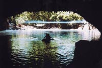
Properties: The cave, with the total length of 110 m. has the deepest point at 27 meters in respect to the cave entrance. The development of the cave had been halted. Because of the connection with the sea, the cave could be called as "marine cave" The cave is dry. The floor of the saloon having the connection with the sea is partially covered with sea water. The temperature of the cave is relationally chilly when compared with the open air.
The Yerköprü Cave is formed by the collapsing of a cave with initial minimum length of 150 meters among the east - west direction totally inside Antalya travertine.
It is planned to be utilized as cafeteria, casino or restaurant because of its size.
Altınbeşik Cave
Location: Antalya, Akseki
The cave is located at the western slope of the deep and very steep Manavgat Valley which is to the east of Ürdünlü village of Akseki District. It takes about one hour of walking to the cave from the village.
Properties: The cave, with the total length of 2500 m. has the highest point at +101 meters in respect to the cave entrance. It is a horizontal and partially active cavern. As the lower and medium parts of the cavern are sometimes active, small lakes are formed at the dry seasons most of the time. The upper level is always dry. The air of the cave is very humid and the average temperature is around 16-18ºC. No animal groups drawing attention are encountered.
Altınbeşik Cave is one of the most beautiful caves of Türkiye. The karstic topography of the environment and the pine forests exhibit a marvellous spectacle. The cave is at the exit end of a very long and big underground system. This big system pulling Kızılova, Kambos and Söbücesuyu ends at the Altınbeşik - Düdensuyu Cave under the Oruç Sinkhole Cave. Therefore, this underground water system with a length exceeding 100 km is one of the longest and biggest karst systems of the world.
Big rock blocks are interesting at the high levels of the cave which loose the activity totally. Among these there are stalactite and stalagmites. The first 200 meters via the cave entrance forms the lower level and is permanently under water. Through the end of the lower level, there is a steep climb of 40 m. This climb and adjasent walls are covered with thick travertine of white color. This forms the most beautiful location of the cave. . .
Gürleyik Cave
Location: Antalya, Akseki District
The cave is located near the Eynir Polje, which is approximately at a distance of 12-13 km. to Aydınkent (İbradi) in northwest. It is approximately at 500 - 600 m distance to the road, at the right side after trespassing Başlar village. But reaching the cave is very hard because of the big limestone blocks on the path.
Properties: After entering the cave, in the first course, a descend from a mouth at 25 m width by stairs is necessary. Especially in spring, it is hard and dangerous to proceed forward with boat because of the high amount of water inside and because of the presence of the sharp and pointed limestone tips at the cave surface. In August, the water level falls and small lakes are formed.
Kocadüden Cave
Location: Antalya, Akseki District
The cave is located at the southwest edge of the Akseki Polje. The track separated from the Akseki-Bucakkışla road at 4th kilometer passes very near to the cave.
Properties: Although the cave has horizontal localities, it mostly develops vertically and decreases down to 155 meters like stairs.
Koca Düden, which drains the surface waters of Akseki Polje river basin is developed on an important fault line formed by the Upper Creates Limestone. Koca Düden holds numerous lakes within and ends with a closed siphon.
Oruç Düdeni Cave
Location: Antalya, Akseki District
The cave is on the path of the incoming underwater flows to Altınbeşik - Düdensuyu Cave.
Properties:The total length is 52 meters. It is about the collapse because of the operation caused by the underwater creek passing through the lower levels of the cave.
Dim (Gavurini) Cave
Location: Antalya, Alanya District
The cave is located at the locality of Kuzkaya village. It is at the west slope of the Cebireis mountain (1691 m.) at the east of Alanya. Reaching the cave by walking is possible either via the Dim creek valley or via the Yaylalı village at the south. To reach the cave from Yaylalı village, a walk of 50 minutes following the watering channels at the skirts of the Cebireis mountain is required.
Properties:The total length of the cave is 357 meters and the cave is horizontal and dry. There is only a quiet small lake towards the end of the cave.
Dim cave is one of the most beautiful caves of Türkiye. It is suitable for a visit as is at the vicinity of Alanya and as the environment is covered with forests and picnic sites. Because the cave was used as a shelter by prehistoric and historic periods, the cave was called as "Gavurini Cave" by the local people.
Beldibi Cave
Location: Antalya
The cave is an under - rock shelter located at the 40th kilometer of the coastal highway between Antalya - Kemer, just after the Çamdağ tunnel. It is at the locality of Oba village.
Properties: The cave is at 25 m. height from the coast and is in the shape of a shelter. As the cave is damaged extensively by natural destruction, the filling layers are flown away by rain waters and winds.
6 layers containing totally Mesolotic cultures were determined. The cultures found inside this cave display similarities with the alizarin, solitarian and tardenovasior cultures of Europe. At the excavations, Flintstones tools belonging to Upper Paleolithic and Mesolotic periods were obtained. Also, at the walls of this under - rock shelter, human, mountain goat and deer drawing sketches are present. The cave is an archeological side which is continuously open to local and foreign tourists.
Büyük Dipsiz Cave
Location: Antalya
The cave is located at the south slope of Alakaya Hill (661 m.) which is at the west of Antalya port 3 km. southwest of Tünek Hill.
Properties: The cave, with the total length of 40 m. has the deepest point at 29 meters in respect to the cave entrance. As the karstic floor water is present at the above layers, the cave is dry. The cave is more chilly than open air. The temperature outside is 20ºC at the beginning of November though the temperature inside the cave is 17ºC.
The cave is formed between the Creates aged residual limestone and by the conglomerate limestone formations of the same age just below this layer. After a narrow entrance, with an average slope of 25º the cave proceeds towards north.
 Damlataş Cave
Location: Antalya, Alanya District
The cave is located inside the borders of Alanya and is at the coast. It is 3 km away from the city center.
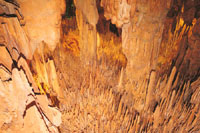
Properties: The total length of the cave is 30 m. and is dry ve horizontal. It covers an area of total 200 m. The cave is 15 meters high and has a marvelous vision formed by numerous stalactite and stalagmites. With the carbon dioxide gas, high humidity, low temperature and radioactive atmosphere, the cave is extremely beneficial for asthmatic patients. Therefore the asthmatic patients form the most dense visitor groups. The formation period of the stalactite and stalagmites inside the cave are estimated to be between BC 20.000-15.000 years.
Derya Cave
Location: Antalya
The cave is located inside the Atatürk Park which is between the Konyaaltı Street and coast.
Properties: The total length of the cave is 124 m. and the deepest point in respect to the entrance is at 35.65 meters. The cave is vertical. As the south section of the cave is inside the sea, it could be named as "marine cave". The cave is dry and its development had been halted. The sections which are at the sea are covered with the partially salted sea water.
There are a small amount of stalagmite and wall travertine developed at the grand hall though towards south the amount of stalagmite ve stalactite increases. In this section, sweet water springs gush out of cracks and mix to sea water. There is a second exit to the 40 m west of the main entrance. With the width of 0,5 meters ve1 meters length, the entrance is seen as a widened crack.
Air is relatively chilly in respect to open air in summer.
Çimeniçi Cave
Location: Antalya, Alanya District
Çimenini cave is located at the vicinity of Şıhlar (old name Şeyhler) village, at the southern skirts of Cebireas mountain , to the east of Alanya. Reaching to the Şıhlar village is by the 15 km stabilized road branched from Konya- Gazipaşa highway in Demirtaş sub district and from this village the cave is at a short walking distance. There are historic remains and traces of Romans around the vicinity of the cave.
Properties: The Total length of the cave is 10 meters and except for a steep climb it is totally horizontal. Because the thickness of the limestone in which the cave has developed is in a limited and congested area, the cave is totally dry hydrological. The atmosphere of the cave is relatively chilly when compared with open air. The average temperature is around 17ºC - 20ºC.
The cave has been formed by numerous connected chambers and two layers. The cave has a single aperture among the direction of East, Southeast - West initially and later the chambers were formed as the aperture was divided by travertine pillars. There are numerous chambers at the primary section and is completely horizontal.
The cave then proceeds to the second section via a steep climb of + 57 meters. This section of the cave is +10 meters higher than the entrance and is formed by two big chambers. The cave is extremely rich on the basis of travertine deposition. The travertine pillars forming the chambers cover most of the space. The side walls are decorated with drapery travertine.
This cave is interesting because of the beauties of the natural formations and accompanying historic remains in the vicinity. The usage at the historic periods ware understood though no written documents were revealed by the recent studies. The cave has not been involved in the touristic locations.
Mahrumçalı Cave
Location: Antalya, Manavgat District
The cave is located to the east of Mahrumçalı quarter which is to the east of Gebecek village northeast of Manavgat. Reaching the cave is possible via all sorts of vehicles.
Properties: The total length of the cave is 157 m. and the deepest point in respect to the entrance is at - 36 meters. The cave is semi horizontal and semi active. Water flows inside the cave only in the precipitant seasons. The temperature of the cave in summer months is around 16 - 18ºC.
Geology - Geomorphology The cave is developed at the contact point between the Cebireis formation and the Mahmutlar formation which is below. The cave is inside the dolomithic limestone and over the micaschist layers and dives towards south by 15 degrees concordant with the curvature of both layers.
Peynirdeliği Cave
Location: Antalya, Kemer District
The cave is located at the Gedelme Plateau locality. There is a road connecting Kemer district to Gedelme plateau. With a short walk of approximately 4 minutes is necessary to reach to the cave entrance from the village center. There is a historic wall and ruins belonging to Byzantium at 65 m. north of the cave.
Properties: The total length of the cave is 74 meters and the deepest point in respect to the entrance is at - 19 meters. The cave is dry and is mostly vertical.
Most part of the cave is dry. There is only a small lake at the end and the deepest point of the cave. The temperature of the cave is 17ºC in Autumn. As the cave entrance is relatively large, the temperature of the inner cave changes relatively to the conditions of open air.
There are stalactite, stalagmite and pillars developed inside the cave. The surrounding natural beauties and historic ruins makes the cave more attractive.
Tilkiler Cave
Location: The cave is located inside the area of Oymapınar Dam at Manavgat District, in Antalya.
Properties: The cave has developed horizontally and is an active cave with a total length of 7 meters. The water level inside the cave rises in spring.
The cave had been discovered by encountering a natural gallery during the construction of injection galleries of the dam. As the cave has been developed inside Conglomerate, the cave has significant scientific value.
Sırtlanini Cave
Location: Antalya, Kemer District
The cave is located between Yukarı Çamarası and Narlıgedik villages of Karacasu sub district. Reaching the cave from both of the villages is possible. A walk of 20 - 25 minutes from Narlıgedik village is necessary to reach the cave. The cave is close to the Aphrodisias ruins.
Properties: The total length of the cave is 348 meters (Main Gallery: 147 m.) and the deepest point in respect to the cave entrance is at -32 meters. It is a horizontal and dry cave.
The cave starts with a very narrow mouth. After 4 - 5 meters the main cave opening is reached. The saloon is divided into 5 - 6 sections by the pillars developed side by side and finally forming walls. All of the chambers connected to this saloon is decorated with stalactite, stalagmite and pillars. As the temperature outside is 28ºC and the relative humidity is 44 percent, the temperature inside the cave is 17ºC and the humidity amount is 85 percent.
Aslanlı (Yaren) Cave
Location: Antalya, Manavgat District
The cave is located at the Plateau locality of Kirazlı Village. In order to reach to Aslanlı Cave, a walk of about 30 minutes is necessary, starting from the Dereboğazı locality which is at the 3rd kilometer of Kirazlı - Kuşadası road.
Properties: The total length of the cave is 110 meters and the cave is partially horizontal, partially vertical. It is a dry cave. The temperature in October is 18ºC.
The cave has developed inside the dolomithic marble of Mesozoic age and on a large fault. After a steep downwards descent of 6 meters, the cave descends towards west with 26 degrees among a big fault roughly in the direction of east - west, and after 40 meters the cave enlarges and the floor looks like an inclined saloon. The floor of the saloon is covered with muddy ground and rock blocks fallen from the ceiling. The stalactite and stalagmites formed drapery and flag travertine on the walls. The name of the cave comes from one of the stalagmite which looks like a sitting lion.